I dont think its a stalemate at all though. I mean it is when it comes to the difference in views, but I think you just want to ignore certain things concerning the place. Again, in the span of 2-3 years (not 3-5 like I said) Admiral Byrd died, NASA was created, and Antarctica made off limits. Dont see how one can ignore that, then call themselves a truth seeker. And in the only TV interview we have of him concerning the place he explored, he said the gov't would be VERY interested in the place over and over again, yet all I've ever known about the place is that there is alot of ice there. So I know Im not wrong for putting two and two together that they're probably hiding something there...And with the icing on top being that there is a mountain range named after the Rockefellers there, its an open and shut case for me.
You keep repeating things you have no proof of, or are inserting conspiracy or conjecture into. I'm not as conspiracy minded as you, this is true, and you know this, so I am of course going to look at this from a different perspective. Admiral Byrd died, yes, at the age of 68, 3 years after the interview we've been watching. Do you have anything to insinuate he had planned on releasing some sort of information that would warrant him being killed? Otherwise, it is far more likely to me that he died as they say he did. I understand that as a truth seeker that is not something you may be willing to accept, but I'm trying to work with reality, not unknown possibility here.
As for NASA being founded a year later, I personally don't find that fishy or even related to Antarctica or Admiral Byrd, so it is circumstantial at best. Again, I understand that doesn't halt your opinion on the matter, but at least understand you aren't going to convince any of us unless you have something more involving that. Perhaps your goal isn't to convince anyone of any of this, but then I don't really see the point otherwise.
Antarctica is not off-limits. That is a fantasy as far as I can tell, and something you've not really been able to prove is the case. Jarl Andhoy's issues with authority can be explained in a rational manner, as I believe I have done, and I've offered other sources of similar, or perhaps better reliability that say you can visit Antarctica and sail around it and all sorts of thing. If I remember correctly, you can even fly over it at certain times if you want.
As for why the government is interested in the place, I go over this at the bottom of this post, which I wrote first. In summary: natural resources, which was the main goal of his expeditions, which is why they were funded by John D. Rockefeller and also why the mountain range is named after him. He says in that interview that they have found coal deposits and believe that there is likely oil there as well, and potentially uranium. All things the governments of the world would be VERY interested in. He even states that he thinks there may be enough resources there to fuel the world for the foreseeable future. The problem, of course, is getting to those resources through miles and miles of built up ice in likely THE most inhabitable place on the face of the Earth.
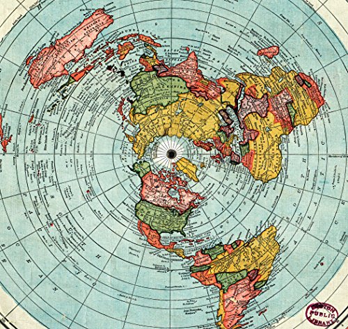
And the model they use may very well be incorrect. But how exactly cant that route exist on that flat earth map?
It can, but as I said, it would have been the longest and most dangerous trade route in human history. I can't say I'm surprised that you can't see this as being the case, and I'm not sure if I'll be able to properly explain it to you just via words.
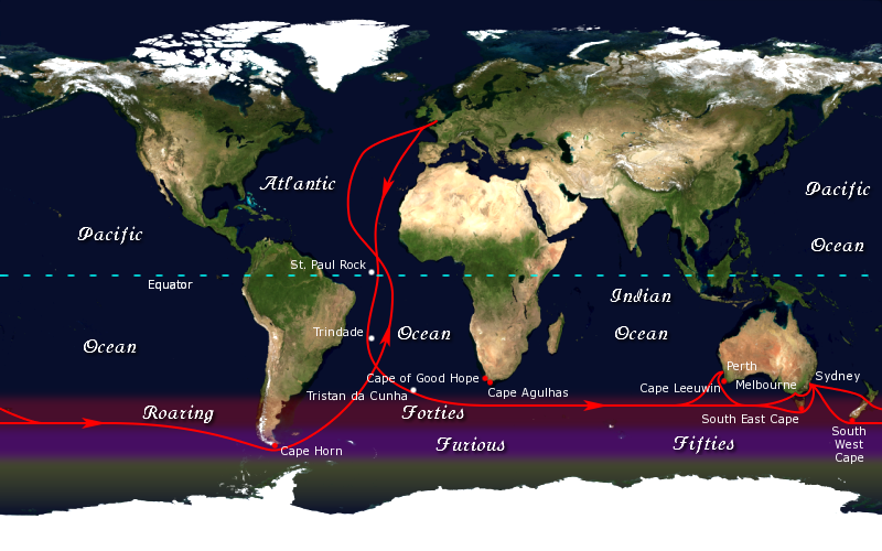
Try to imagine the globe. Now notice how the bottom is much smaller than say the middle, where the Earth is at it's widest. So, in order for the Cape Horn trade route to be feasible for these men on ships to use, it would have to be shorter than say just sailing from Australia, back around Africa, and then up to the UK. Because they understood the shape of the Earth (a globe), they understood (and proved by using it) that if they sailed from New Zealand and headed East above Antarctica they could go the shortest distance around the bottom of the globe and then swoop up around Cape Horn and use those channels to reach the UK far faster than the alternatives.
Now, according to the FE model, to use this route they would be sailing for months across open sea before reaching Cape Horn and heading up to the UK, rather than say weeks. I can't possibly know the actual differences between globe and flat Earth because flat Earth isn't real, but if you just really look at it yourself you
should be able to understand that the difference of distance traveled on open sea between the two models is
massive.
I didnt think about this when you first posted this to me, but what exactly is different between the route you posted and the one that would have happened on a flat earth map? Either scenario you go South (South on flat earth being AWAY from the north pole) than east (east on the flat earth map being the opposite direction than the moon/sun are moving in your graphic). Its the same easiest route either way. And the thing about your map, is that its not fit to scale (of course). So it makes Australia seem much closer to Africa than it actually is.
Right, just look at a globe, try to imagine the distance between New Zealand and Cape Horn there, and then look at the FE model and try to imagine the distance between New Zealand and Cape Horn there. If you actually can't understand how different that would be, then unfortunately I don't believe there is any hope for you.
To be continued, post was too long.